Hi, friends:
This is a story about our travels to B.C. and Alberta, but it’s primarily designed for our friends who plan to take a similar trip in the future.
So it’s long and relatively detailed. But it’s also my memories of our trip.
I’ll start out with some tips:
Things to think about before traveling/camping in the Canadian Rockies:
The National Park camping facilities are terrific. If you go on line, you will see a selection of campgrounds at which you can make reservation Note that there are many more campgrounds than are shown on the website.
The larger campgrounds, especially those with electricity hookups, fill up, so it’s a good idea to make reservations at those – well in advance, if you’re going in the busy season. Every time you reserve on line, you’ll be charged an $11 fee. . . so if possible, make as many reservations as you can at one time. Otherwise, you’re adding about a third of the cost to each stay.
Click here for a great resource for national parks camping:
CanadaParksCamping10001
The other campgrounds at which you can’t make reservations are terrific, too. They are on a first-come, first-served basis. We were able to get into several of these. While check-in time is at 11, you can go earlier and try to get in, in case people have checked out early.
Bugs are a big deal. If you are sensitive to mosquitoes, before you leave the car at any time, be prepared to protect yourself. I was in pretty good shape, until we walked up to Bow Glacier, where the apparent dearth of flesh created horrifying swarms of biting bugs. By the time I slathered repellant on (maybe three minutes), it was too late. The same thing happened when we got out of the car at a remote campground on the Columbia. Again, if you are sensitive, carry lots of anti-itch cream. It’s almost impossible to avoid getting bitten.
Canadian dollars are coins called Loonies, which would seem to be an insult to the queen, whose picture is on them, but I guess she doesn’t mind.
We had been advised to take U.S. dollars, but in fact, that’s not the best. Some places don’t take them, some will just take dollar for dollar, and some will give you a less-than-realistic exchange rate. The best thing is to use a card or get cash from an ATM.
The town of Banff and Lake Louise are quite beautiful – but they are not the most spectacular nor are they far from the only places to go. In the busiest seasons, missing those two places wouldn’t be the worst thing that could happen. We thoroughly enjoyed visiting Kootenay and Yoho National Parks, even though we’d never heard of them before we planned our trip. There are countless stunning places in both those parks, although they are not well known in the U.S.
Expect to find super busy spots everywhere – but in most places, once you get away from the highway, things are much more peaceful. Some places you can get in first thing in the morning, but we think late afternoon is better because it gets quieter the longer you stay.
If you want to camp your way through the Rockies, you might think about renting one of the many styles of motorhomes now available. We saw lots and lots of rented camping units everywhere we went. Most were from Canadian companies like this one: http://www.canadream.com/. Many of the ones we saw weren’t any longer than the Sprinter. The smallish ones seemed really convenient, particularly because several places we went prohibited or restricted longer RVs and trailers.
The border! We thought we were prepared for the border crossing – with car registration, insurance, etc. It turns out, we prepared for all the wrong things.
We are scofflaws! On the way into Canada, we forgot about some bottles of Oregon wine we had taken as gifts. So not only did we have too much (they only allow two bottles per person), but we seemed suspicious because we didn’t claim everything. (They did search the entire van . . . ) But the customs man was very nice and charged us less tariff than he could have. Still, it was $80.
Then, coming home, we were conscious of alcohol, but we didn’t pay any attention to our refrigerator full of vegetables. The U.S. folks didn’t search the whole van, but they did go through the fridge and waved the green onions at us, which we did not report (again, what scofflaws!). They confiscated most of our veggies.
I guess the message is: check out the expectations before coming and going. We just spaced out that part.
It’s worth planning some stuff ahead. For example, just before we left, we learned about this great place to visit in Yoho Park – that requires reservations three months in advance. But by far, most stuff doesn’t require any preplanning.
CanadaParksCamping10001
OUR TRIP
We left the Wenatchee River Festival on Sunday afternoon, June 19, and drove to a state park on Lake Chelan for a picnic lunch. This decision ultimately led to a two-night stay at the campground (showers, neighbors who had been at the festival, other nice people), and a chance meeting with Ron Clark, who advised us about possible solutions to our battery glitch (another story for another time).
Tuesday, June 20: Who knew northeastern Washington was so beautiful?
We drove up Highway 97 to Highway 20 east through the Selkirk Mountains. Shortly before the Highway turns north, we stopped at a National Forest Service park with three campgrounds on Lake Thomas. The one called Lake Thomas has limited trailer-size access, so we were the only ones in this lovely campground right on the lake. Highly recommended! Bring bug spray.
Wednesday, June 21: Canada is beautiful and Canadians really are nice.
We drove up Highway 20 to the border, where we had a lovely interaction with a nice guard who realized that we didn’t know there was a limit of two bottles of wine per person, and who gave us a break on how much we had to pay in tariff. (Canadians really are nice, aren’t they?)
They went through every inch of the camper, including the safe, but they didn’t make any comment about how cute it was.
Oh, well. We get enough comments.
Once into Canada, we turned right on Highway 3, which took us through more of the spectacular Selkirk Mountains. We turned north on Highway 93/95, and started gasping at the site of the craggy Rocky Mountains to our right and the snow-covered peaks of the Columbia Mountain Range to our left.
After a while, the Columbia Lake appeared on our right. It’s the headwaters of the Columbia, and is fed by snow melt from the Rockies and the Columbia mountains. The Rocky Mountain Trench separates the two ranges, and there is some interesting stuff about the river system there which Matt will be happy to share.


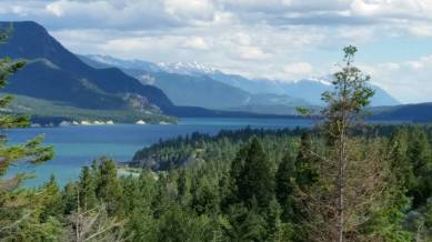
Radium Hot Springs Village is a booming tourist town right on the Highway. But just up the road there’s a very big but very lovely campground called Redstreak, park of the Kootenay National Park. It’s got lots of sites, but they are spread out, so it feels private. We are in H 14, which seemed to have the most space around it – and gives us a view of the Columbia peaks. (Friends who may stay at this campground – we think we got the best site.)
We took the trail into town (kind of steep with some intimidating wooden stairs, but worth the walk), turned right and ended up a great pub with seven kinds of regional micro-brews.
Redstreak has water, electric and showers. Yay. (Electric charging has become important because we’re still having a bit of a problem with the electrical system.)
Thursday, June 22
We drove up to McLeod Meadows Campgrounds on Highway 93, which continues onto Lake Louise in Banff National Park. We already have used up our quota of “wow,” and are moving into, “whoa” and “ow!” Spectacular peaks on both sides. While Matt says that the Colorado Rockies are higher, what’s amazing here is that that snow-covered peaks and spires are continuous on both sides.
They are also notable for their amazing shapes and ruggedness.
McLeod offered a lovely camp site right on the Kootenay River. Great camp grounds . . . lots of sites, but again, it feels very private, and when we arrived there were few sites occupied in our area. For you potential vacationers, McLeod doesn’t take reservations.
In the afternoon, we took a hike to Dog Lake. The trailhead starts right next to our campsite. We crossed a beautiful bridge across the Kootenay (same river that’s called Kootenai in Montana) and arrived at a little trail intersection. We took a bike path/old road north for a while, knowing it would loop back toward Dog Lake.
Apparently, we arrived early in the season, and we had to climb over, under or bushwhack our way around a number of downed trees. Same on the loop up to Dog Lake.
It was a steady, but not too intense, climb – and worth the walk. Dog Lake, like everyplace else here, has gorgeous views. The forest is spongy moss – really yummy to walk on – and we saw lots of beautiful wildflowers on the way. Dog Lake is pristine, surrounded by peaks on one side and lovely marshes on the other.
This was our first real encounter with mosquitoes.
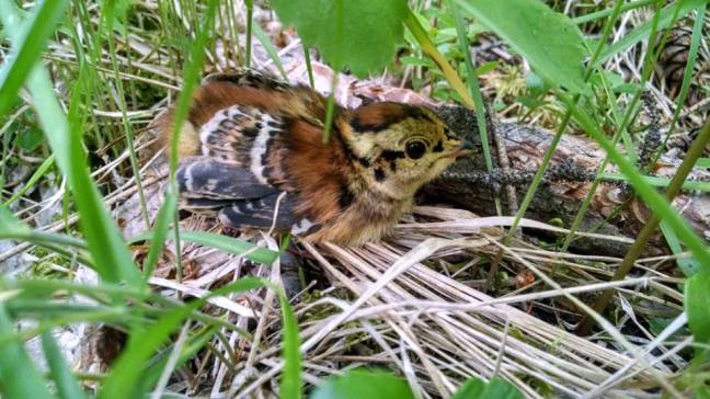
Top event of the day? Probably when a grouse ran onto the path, er, grousing. Matt said, “She wants us to follow her.” That meant she was trying to lead us away from a nest. Matt, quickly recognizing this behavior, tiptoed to the spot from which she had emerged. Gently moving aside the grasses, he found a teeny baby grouse in a nest. He was able to snatch a photo. Mrs. Grouse kept trying to steer us away. After a while, she was satisfied that we weren’t going to harm her babies, and she apparently went back to the nest. At least she left us alone.
In the evening, we went back to Radium Hot Springs for a little while. (By the way, the hot springs appears to be a big swimming pool. At 7 p.m. it was filled with swimmers. Not a funky hot springs like the ones we’re used to in Oregon.)
On the way back to the campground, we noticed a sign with an illustration of a bear, surrounded by flashing lights. We commented on that, wondering if bears really cross at a particular place. About three minutes later, we saw a black shape on the side of the road, which indeed was a little black bear. Very cute, if you dare call bears cute.
Friday, June 23: Jaw-dropping beauty and baby goats
This morning, we drove farther north on Highway 93, maybe 30 or so miles, to the Stanley Glacier Trail. About a third of the way there, we saw another wildlife sign: this one with lights circling a drawing of a goat. Remembering our bear siting, we speculated about goats. Just then, we saw 15 or more mountain goats, including some babies, running down the rocky hillside.
Matt slowed, as even though there was a concrete divider next to the highway, he knew they were capable of jumping it. They did not, but we got a great view. Unfortunately, we couldn’t find a place to stop and watch them. It was lovely, though.
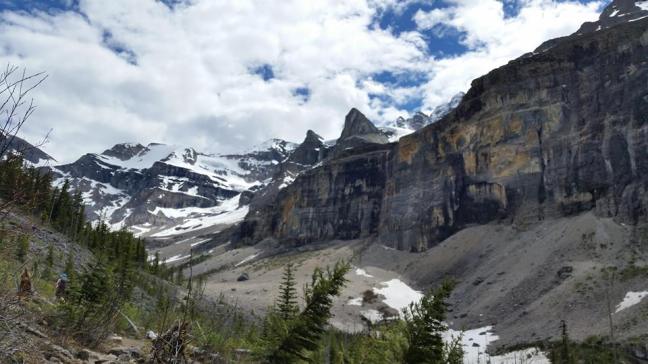
We got to the Stanley Glacier trailhead, which had quite a few cars. I’ll leave it to the guide books to describe the trail, but as you can imagine, much oohing, aahing and holy cowing happened. It’s a great walk – kind of steep at first, flattening out but with rocks, but worth it for spectacular streams, sheer rock walls, a great view of a glacier, wildflowers, and, well, you know, general great stuff.
On the ride home, I saw the goats at the top of the hillside. Lovely.
Note: Weekends get busy, and we will be here over the three-day Canada Day weekend. It appears that campgrounds with electricity and that take reservations get booked in advance, so you may want to make reservations if you will be here over a weekend. McLeod Meadows in Kootenay Park, like other less developed campgrounds, doesn’t take reservations. We are told that if you get in early, these campgrounds and the ones in Yoho, where we plan to stay next weekend, should have space. Today is Friday, and the campground we’re in now is only beginning to get filled. Next weekend may be different as school will be out and it’s a long weekend, but we plan to hit one of the Yolo Park campgrounds by Thursday. We’ll let you know what happens.
Another note: the visitor center right by the entrance to Redstreak has free wi-fi. We used it during the day from inside the building, then sat outside the center last night to use it. Nice. Once outside of Radium Hot Springs and Redstreak, there is no cell service inside Kootenay Park.
Saturday, June 24
Note: Before I forget: Apparently one of the best places in Yoho National Park, and perhaps the whole area, is called Lake O’Hara. It is so special that they restrict visitors by requiring you either to hike in (something like eight miles) or take a special bus.
The thing is, you can’t reserve the bus more than 90 days in advance, but if you reserve it 89 days in advance, you’ll probably be too late, according to my guide book. So if this lovely area sounds interesting to you, pay attention to the timeline.
Now, back to today:
We stayed a second night at McLeod Meadows Campgrounds. Yesterday, we got home in time to prepare a meal, clean up and have enough energy to play some music – a first on this trip. We sat in our bugproof shelter (a must, as this camp site is right on the river) and played until about 10:30. Given the latitude and the fact that it’s around the solstice, it stays light very late. And it’s Central time, so we’re an hour ahead of ourselves. So it hardly seemed late at all.
This morning, we packed up and got ready to go, but before we left, we felt we had to do some picking on the suspension bridge across the Kootenay River. It was sunny, warm and lovely. The bridge is skinny, so we’d have to stand up when people wanted to cross it, but we thought it was a good tribute to the river.
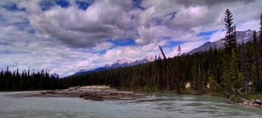
We headed north again on Highway 93, to a picnic area called Paint Pots. There is a little trail leading to some unusual water features. We chose not to take it and proceeded instead along a longer trail (I’m thinking it was 3.2 km) leading to Marble Canyon.
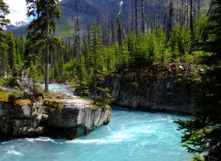
That hike was along the beautiful Vermillion River. It’s named vermillion after ochre in the rocks, but the river is a color green unlike anything I’ve seen. Across the river is, of course, a series of snow-capped peaks. The hike was fairly easy, although it got pretty hot for a while.
Just before Marble Canyon the river flows through some amazing rock formations. At Marble Canyon, there’s a loop where Tokumm Creek, in conjunction with some seismic activity, has carved a stunning path through the rocks. You can also reach Marble Canyon from a parking lot right on Highway 93.
We walked back along the Vermillion River to the Paint Pot parking lot, but we were too pooped to take the final loop to the paint pots.
We drove back to Redstreak Campgrounds, where we had reservations, and took ourselves out to eat in Radium Hot Springs. Early to bed.
Final notes on leaving the Kootenay Park and Highway 93, which we drove at least once a day. We saw the goats several more times collected by the highway, enjoying the salt lick. We never saw the bear again.
Sunday, June 25/ Monday, June 26
Today was, sort of, our day of rest.
It started with laundry and groceries in Radium Hot Springs (the laundry is in the gas station at the beginning of Highway 93, FYI).
Then back up 93 into Banff, singing Across the Great Divide at the appropriate time – that would be when we leave B.C. for Alberta.
We crossed Highway 1, the Trans Canada Highway, and went about a mile, to reach the place we will call home for three nights: Castle Mountain Campground.
The campground is lovely. It’s got about 40 spots, but the way all these campgrounds are set up, it feels like there’s a lot of privacy. There are lots and lots of trees, and it doesn’t feel like you’re camping on top of other people.
It doesn’t have showers, but it has a really nice bathroom with flush toilets and hot and cold running water. It also has something terrific: a big clean sink with a long stainless steel counter outside the bathroom building, for washing dishes. That’s a terrific asset – we have started using it to save our own water and reduce use of our graywater system.
Yesterday afternoon, after getting settled here, we decided to drive to the town of Banff. It’s a cute touristy town with amazing scenery – mountains all around and a lovely river flowing through it. However, it’s sort of the worst of all tourism.
Sunday evening around 6, it was hard to walk down the street because it was so filled with tourists. The cool part was that it was the most international place I’ve ever been – aside from the native French speakers and the Chinese who have moved to B.C., there were many other people from East and Central Asia and other parts of the globe.
It’s too bad they all were trying to walk on the same sidewalks at the same time.
Banff has lots of high-end chain stores. It also has some of the kitchiest tourist traps I’ve ever had the pleasure of seeing. Talk about cultural appropriation (a term which Matt and I have been debating quite a bit). There’s an awful lot of First Nation-looking stuff that may not have been made in either Canada or the U.S., let alone by real First Nation people or Native Americans. OK, that’s a whole other discussion.
Anyway, there’s a tremendous amount of crap here, along with some nice stuff.
The other thing that strikes us is that Banff, like many tourist towns, tries to pretend it’s somewhere else. There’s the Bavarian theme. . .ugh. Then there are lots of British themed stores. And of course, Starbucks; McDonalds and Subway.
We took a walk by the river and stopped at a place called Coyote’s, where I had a great bowl of sweet potato and corn chowder. Mostly, we tried to scope out what else was worth doing.
This morning, we got up early to get into town and catch a parking place. We took a walk to Bow Falls – nice easy, and short walk from downtown. We found a bicycle pump and tried to go on another nearby hike – but the parking area was so packed we thought better of it.
Turns out that some things you want to do in the whole national park of Banff is get there first thing in the morning.
Another thought – imagine a whole city inside a national park. How does the administration work?
After town, we came home and ate and napped. We are learning that you don’t have to stay out all day.
Then we went to Johnston Canyon, another place that had been packed when we passed it earlier in the day.
Johnston Canyon is about a 1.5 mile walk up a not-too-steep hill. The first waterfall is at about .5 miles, the second is around 1.5 miles. It’s possible to go farther to see some other scenic things, but we chose not to.
When we arrived, hundreds of people were coming down, and quite a few were still going up. Things slowed down considerably after the first falls.
It’s quite a lovely and astonishing walk. But it’s unbelievable how many people took that walk – and must do so every day.
Our first friends
Our first night in this campground, a lovely man from Montreal stopped by to talk about the van. He and partner had purchased a local transit shuttle bus which they are converting into a camper. It is about one third wider than Creature, and seems super spacious, but it still is not a big vehicle. They had built in a sink and cabinets, and had put their own bed in the back – with room on either side to walk around.
Julien and Viviane are both engineering professors, and she is an electrical engineer, so they should be able to make something great out of it.
The nicest part was meeting some very engaging people – and starting to think about Montreal. Viviane came over after a bit to tell us how to get alerts about the Northern Lights . . . apparently there have been some recent solar flares, and the University of Alberta will send out emails to let you know when the lights are occurring.
Thoughts on environmental awareness in Banff and the Canadian Parks
Banff is going solar crazy. We watched today as workers continued their work installing dozens of solar panels on a small sports arena. All the publish washrooms in the city have solar on top, as do many other city buildings. Somehow, the city’s use of solar reduces the cost of solar installations for private citizens.
The next thing we noticed is the bicycle pump/repair setup in a giant parking lot near a giant public bathroom. It is a post with a tire pump attached, and a bunch of repair tolls dangling from the top.
Every public facility has bottle and can recycling. We noticed this particularly because the U.S. national parks and forest service campgrounds we stayed in had no recycling. I must remember to write to my congressman.
Thoughts on women’s bathrooms
The Canadians really get it. The women’s bathrooms are huge – lots and lots of stalls. It was really notable at that very busy tourist attraction, Johnston Canyon. Despite the crowed of women coming off the trail, there was no waiting. O’ Canada!!!!
Tuesday, June 27
Today was spectacular in a way we didn’t expect. We weren’t sure what to do, but thought we would check out some of the close-in trails near the city of Banff, even though we didn’t want to hang out on the city streets.
Eventually (after a second trip to the bike shop to learn how to use the bike pump. . . even the sales guy had trouble figuring it out) we agreed to try the bike path around Vermillion Lakes.
And, my oh my, that’s got to be some of the most amazing scenery anywhere, even compared to what we’d already seen. The bike path continues from city streets and starts very close to downtown. It’s not that long, but every inch is breath taking.
And what was perhaps most amazing was how few people we saw on it: a few pedestrians at the beginning; maybe a total of 30 other bicyclists and more cars . . . yes, it’s odd, cars are allowed on the path). But there were times when we so no one else, and in late afternoon it was very quiet.
Considering how crowded the city streets are, it was truly amazing (and also somewhat disturbing that so few people took the time to see this amazing part of town).
On the ride home, we noticed cars slowing (and one person just sort of stopped in the middle of the road).
We looked where people were pointing – and saw a gorgeous caribou.
Last night in Castle Mountain Campground. Goodbye to the gurgling creek right next to the van.
Wednesday, June 28/Thursday, June 29
The phrase for Wednesday was Holy Mackerel. The phrase for Thursday has been, “How can it keep getting better?”
Wednesday morning we headed to Boom Lake, yet another incredibly scenic spot surrounded by mountains. The hike started out a slow uphill for about a kilometer, then gradually evened out. Some spots were fairly muddy and took some negotiation, but all in all it was a pretty benign walk. . . mostly through forest, but with glimpses of mountains and little creeks along the way. It was 4.8 km each way. A lovely walk – even with some rain – and quite the reward at the top.
Having packed up at Castle Mountain before our hike, we headed to Lake Louise Campground, where we had a reservation. We got our spot and headed to Lake Moraine, which we’d heard was spectacular. We’d also heard that parking is limited, and sometimes they just don’t let people into the area. We left the campground around 4, hoping that people would have started leaving for the day.
And in fact, the huge parking area had started to empty by the time we got there. And we were so glad.
Of all the amazing scenery we’d observed so far, this one was the most awe inspiring. Lake Moraine is as green as can be, and it’s surrounded by peaks, including a range called Ten Peaks. I can’t describe what makes it so spectacular, but it truly is.
While people had started to leave by late afternoon, it was by no means a solitary experience. Kids were running up and down paths, young people were perching on horrifyingly high places to take each others’ photos, people were pushing their way down stairways – we couldn’t imagine what it would be like at peak times. Nonetheless, it’s still breathtaking.
We drove into Lake Louise Village, which is mostly a little strip mall adjacent to some resorts and nice restaurants. We had a terrific meal at a place called the Outback, a pub-style restaurant which indeed is out back of one of the resorts. I say pub-style because it’s still expensive, but you could wear your hiking clothes and not get the same looks that we received from the snooty hotel staff when we walked in to ask directions.
We had heard that campgrounds would fill up this weekend, so we wanted to get an early start to Kicking Horse Campground in Yoho National Park (it’s the only one of four campgrounds with showers.) But first, we thought we should at least stop and look at Lake Louise . . . so we drove to the lake, only to find what Matt well described as a Disneyland like feeling – hundreds of people line up to look at the lake.
We stayed 10 minutes. We may try to go back when it’s less crowded. But it turned out to be a good thing that we left when we di, as we got the second to the last spot at this campground.
Which we love. Even though we’re in the trailer section — which has no trees – we are happily surrounded by gorgeous peaks. And we have enough sun to make full use of the solar panels. (Continuing perplexipation from the battery charging system on the Sprinter, but no need to go into that here).
We took a short hike from the campground to look at an old railroad engine that was just abandoned in the middle of the forest after the narrow-gauge railroad was abandoned. Then we headed into the town of Golden, where we found a little health food story that seemed totally unappealing, and which we left in favor of the IGA. We are happily provisioned for days to come.
Oh yeah, did I mention? Grocery stores have no beer or wine. You have to go to the liquor store. Fortunately, even the smallest towns have at least one of them.
Friday, June 30
The long days are delightful, and a little disconcerting.
We knew we’d be up here at the summer solstice, and that the days would be longer than normal because of the date and because we’d be so far north.
But daily, we are astounded by the time. It feels like 7:30 or 8, when it’s really 10 p.m. Yes, the northern thing really makes a difference. It must be affecting us, because we don’t seem to be sleepy at the usual time.
Today, we visited Bow Glacier – a walk around Bow Lake, ending in a sharp ascent that took us close to a waterfall that is basically the source of the Bow River, which flows all the way to the town of Banff.
Bow Lake is on the Icefield Parkway, which is supposed to have the best scenery in the whole park system. From what we saw, that’s true. And Bow Lake is smashing.
Thought for the day: Banff and Lake Louise have astounding scenery, but they became the center of the park system because the railroad went through early. The railroad folks did everything they could to draw tourists to these mountain settings, so there are classic old buildings in both towns. (Lake Louise isn’t nearly as built up as Banff, but it is a historic tourist attraction).
What we realized today is that if you have limited time – or limited patience with tourists – you could easily skip those two places and get as much Wowee-Zowee scenery farther north.
We only went up the Icefield Parkway about 40 Km, but we were enchanted the whole time. And Bow Lake is every bit as beautiful as Lake Moraine. And while the tourist buses arrived at the lake, there was nowhere near the crowd that we’ve seen at other sites. And after a few minutes, we saw only a couple dozen people for the rest of the walk.
For those considering this hike: The first half is very easy – just a walk around the gorgeous lake.
I found parts of it a little edgy making, as it required some walking over fairly small logs; had some narrow and rocky paths next to relatively sleep slopes; and ended with what was for me (who doesn’t do hills very well) a strenuous bit, including some wooden steps that felt like they were designed for Andre the Giant.
I think going later in the year will alleviate the need to walk over logs, etc. (it seemed like the lake was high from snow melt and lapping over the trail, but that this situation would go away during the summer).
Most people had little trouble on the trail – I just get easily winded and am, well, a little clutzy on uneven trails.
The top truly is fabulous: you are overlooking the headwaters of the Bow River in a stupendous canyon, and you are nearly eye level with the waterfall that starts it all. The glacier is out of site at that point, but at one point filled the whole canyon.
This is the place where the bugs nearly did me in, however. They descended on us like we were the only living things within miles. I could see 15 or 20 on Matt’s shirt at one time. Smear anti-bug stuff on before you reach the top.
After we came down, we decided to go a few miles farther up the parkway to the Bow Summit Overlook. For some reason (possibly because there’s a view that just requires a 10-minute walk), this was another Grand Central Station meeting place, with tour buses and hundreds of people. The view is another terrific one, but the crowd made it kind of uncomfortable.
We did learn that the glacier we could see from the lookout had receded by 2 km in the last 100 years. This was perhaps the most profound example I have personally experience of global warming. In the middle of this immense natural beauty, we were left with a feeling of hopelessness and some guilt about possibly living at the peak of a civilization that was quickly declining.
Saturday, July 1
Canada Day! We drove to the little community of Field about five miles from our campground. The visitor center was holding lots of Canada day hoopla – lots of family stuff. They also have a very good selection of maps and knowledgeable staff who advised us about future activities.
The Burgess Shale, which was the source of thousands of fossils and filled in a lot of blanks about certain evolutionary stages, is visible from the front of the visitor center. In addition to lots of information about the findings from the shale, the center also has dozens of actual samples. Someday, we’ll come back so Matt can take a tour of the fossil area.
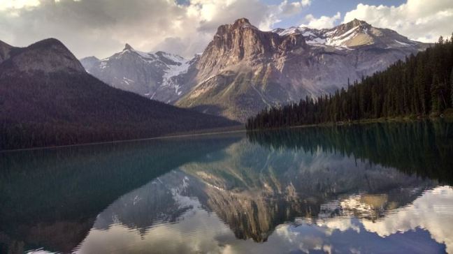
We then went to Emerald Lake. That’s one of those places that is super busy at the parking lot, since it’s a gorgeous view, but it’s easy to get away from the crowds. It’s an easy 3 mile walk around the lake and, as always, the scenery is breathtaking.
Sunday, July 2
Kicking Horse Campground is named after the Kicking Horse River, which is named because some poor railroad fellow got kicked in the chest by a horse while trying to find the best route for the trans-Canada trains. (He lived, but they had been planning his funeral before he regained consciousness.)
The campground is just below the confluence of the Yoho and Kicking Horse Rivers.
Up a road from the campground (there are some tight switchbacks, and trailers aren’t allowed. . . it was even tough for the Sprinter to take one of the curves), is Takakkaw Falls. This is a pretty popular destination. You can drive right up to a view of the falls and walk just a ways to reach the falls. (Lesson: it’s always windy and wet close to these falls.)
Leaving our van at the Takkakaw Falls parking area, we started to hike up to a view of more waterfalls. We took the road to Twin Falls, but we only went about half-way to the top. In the process, we viewed three waterfalls that were all quite lovely.
It’s a fairly moderate climb and about 3 or so miles to get to the third fall, then it gets harder and steeper to get to Twin Falls.
There are also other longer hikes, including some remote camping areas, that start from this trail.
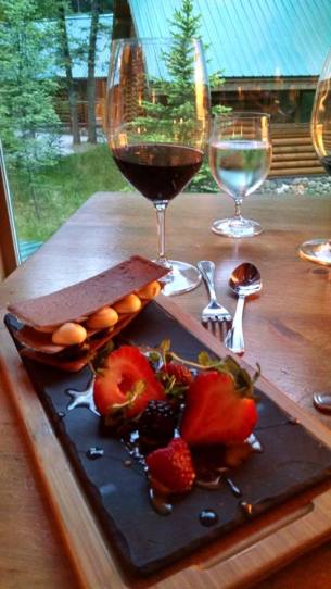
Since Matt’s 60th birthday was Monday, we decided to splurge on dinner Sunday evening at the Cathedral Mountain Lodge. It’s a lovely fancy log cabin with a dining room complete with views of several mountains – and some of the best food I’ve ever eaten. A highlight was gourmet smores: berries; high quality chocolate; homemade marshmallows and delicate crust, not at all like graham crackers from a box. Matt said all that was missing was the charcoal.
Monday, July 3
On this day, we drove back north on Highway 1, The Icefield Parkway. We were looking for last hikes in Banff and Yoho before heading down to the Columbia.
We ended up at Saskatchewan Crossing – which somehow reminded me of a rest stop on the Pennsylvania turnpike: tour buses and a huge gift shop and coffee shop. But we were able to get directions to Warden Lake, which is what we were looking for.
A mile or two south of Saskatchewan Crossing is a ranger station on the east side of the road. Across from it is a little parking area. Cross the road, and look for a little sign in a field south of the buildings, indicating a trail to Warden Lake.
This easy walk is most notable for following the headwaters of the Saskatchewan River and for giving a close-up view of a controlled burn. The lake itself isn’t that spectacular, but once again, every time you look up you see some amazing peaks. A comfortable walk.
We thought we’d try for a peaceful and leisurely period at Moraine Lake before we left the area. Matt was hoping to be able to have some unlimited time to take photos without lots of people jockeying for views.
But although we got to the lake around 6, there was still a long line to get in. We did walk to the end of the lake, and we were able to see a little woodpecker sticking his tiny head out of a snag waiting for mom to come back and feed him.
While the water is still beautifully blue-green and the surrounding peaks are awesome, it’s crazy busy with people well into the evening.
Tuesday, July 4
This day was devoted to learning information that would prepare us for next year’s trip: the next phase of exploring the Columbia River.
So far, we had driven from Columbia Lake up to Radium Hot Springs. We had not explored the area from Radium Hot Springs to Kinbasket Lake, at which point the Columbia becomes a reservoir. One dilemma we’ve had has been how we could get around the reservoir (something we have left until next year).
From our campground in Yoho, we drove along the Trans Canada Highway, Highway 1 to Golden (on Highway 93). Then we drove north toward Kinbasket Lake to check out a “resort” at the south end of the reservoir. We visited the resort, which is cabins and campgrounds and some canoe rentals. We talked to the owner, who talked to us about the limited road access along the lake.
After that, we drove around the south end of the lake to the northeast side, where we stopped at a public campground – which was lovely, but which I determined was intolerable based on the insects. Much discussion ensued about clothing that would make hiking and paddling tolerable, even if we agreed not to camp there.
We drove south on Highway 95 along the Columbia, which at that point is in the last stages of being an unbridled river. We ended the day in Golden, where we camped at a municipal park along the Kicking Horse River.
After dinner, we walked along a bike path that took us to the confluence of the Kicking Horse and the Columbia. Very cool (with, again, the exception of mosquitos). From there, we walked into downtown to visit a brewery. (Matt’s review: too much Bavarian-style clove beer.)
The town recently built a lovely covered bridge over the Kicking Horse River, which connects the bike path to a sweet downtown square, where the town holds a great concert series and other events.
Golden seems to be recreating itself in a very nice way.
Wednesday, July 5
On Wednesday, we took ourselves to breakfast at the Big Bend Café – excellent, and visited Bacchus Books, where we got some very detailed maps of the region adjacent to the Columbia. Bacchus seems to be a central part of the Golden community, with used and new books and a café upstairs.
We drove from Golden south along the Columbia, back toward Radium Hot Springs. Much of the area is protected wetlands and wildlife habitat. We weren’t able to find any good viewing areas, but we will be back to explore next year.
We returned to our old stable campgrounds, Redstreak, for the night and for a last go at laundry. When we drove into town, Matt pointed to something and said, “that isn’t a statue.” It was, in fact, a bighorn sheep that seemed to have wandered into downtown Golden. On the way up the hill, we saw three more sheep in the process of being photographed.
Thursday, July 6
This was our most earnest attempt to access the Columbia. From Radium Hot Streak, we retraced our steps toward Columbia Lake. We stopped into what’s left of the town of Canal Flats. At this point, more than 100 years ago, some well-meaning entrepreneur tried to build a canal between the Kootenay and Columbia Rivers.
For his trouble, a total of two sternwheelers used the canal, each one only once. Soon after, it was abandoned.
While the person at the visitor center told us the canal was no longer accessible, she gave us a map that showed us directly where to go. So we got to see this little stagnant, useless canal and think about the past.
Although she was ignorant of the canal, this person did let us know that it’s possible and easy to find the exact point the Columbia begins.
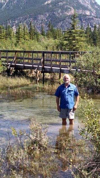
So we drove through some city streets and followed signs to a little walking path. The path leads through some marshy areas to a bridge. On one side of the bridge is marshland. On the other, the water is more free flowing – in fact, the very beginning of the Columbia River that flows to Astoria.
Apparently, the marsh is fed from water seeping underground from the Kootenay River. While the Kootenay and Columbia nearly meet at this point (and would have, with the help of the canal), these major rivers actually flow hundreds of miles in opposite directions – one going north, then west; the other going south all the way to Montana before flowing north and east again – until they actually meet in southern B.C.
Having seen several of the rivers that form the Columbia, we are more excited than ever to continue our journey next year and in the future.
By this time, we were heading for the barn, and Matt drove us back into the states, through Spokane and all the way to Walla Walla. This was our goal, because we had fallen in love with a restaurant called the Saffron Mediterranean Restaurant. It was a good incentive to keep going — that, and it was 100 degrees for most of the trip.
We were happy to enjoy a terrific meal in air conditioning. We are now camped out at the Motel 6, where the AC, while noisy, doesn’t appear to be doing much good.
Final travel day
We left Walla Walla and drove home along Highway 14 on the Washington side. A fitting end to the journey, through the amazing Columbia Gorge, which had inspired our trip.
Already looking forward to next year.
 I really, honestly, am trying to be less political on Facebook.
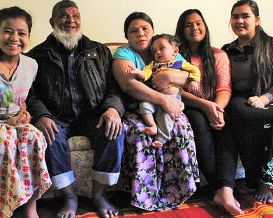
 Margaret with some of the Zambian families that receive goat milk from the organization she and Casey started.
 Gretchen, a few days before her death, with Margaret.